Showing posts with label map. Show all posts

Friday, 8 April 2016

Geography - from Germany to Guyana


I have more cards Germany than from any other country except possibly France, but the French cards have mainly been purchased while the German cards have been exchanged via Postcrossing. Above you can see just a few beautiful German castles.

Below, at the other end of the scale, are cards from countries where I have less than a handful: Gambia, Ghana and Guyana. In fact the map of Guyana is the only one I have from that country and also the only one resulting from an exchange.


Monday, 31 August 2015

Animals of Africa


The shape of Africa made up of all the animals you might associate with the continent, from the largest elephant to the smallest insect.  Maybe not quite the smallest, but there are insects: butterflies and scorpions.  It's fun playing "spot the animal"!  This was sent from South Africa.

Friday, 14 August 2015

Lazy days of summer


I was being lazy in Ireland last week, which would cover August 10th, National Lazy Day in the USA.  However, even though I say it myself, I was being quite active climbing the Hill of Howth, just north of Dublin.

The card is one I bought while there but I sent it to myself in the end. Céad Míle Fáilte means "welcome", or literally "a hundred thousand welcomes".  It's a good many years since I was there, not since I left school in Dublin, but I must say I found everyone very welcoming.

This is a post for Postcard Friendship Friday, hosted by Beth at The Best Hearts are Crunchy. You can visit her to see if she was lazy or not.

Monday, 6 July 2015

Monaco and the Côte d'Azur


A new - for me - map of the Côte d'Azur showing the position of Monaco.  I bought it ready stamped with old stamps, and probably over-priced, but I liked it.  It seems slightly odd that they have shown the casino towering above the Prince's Palace.

Monday, 11 May 2015

The Stuart Highway


John McDouall Stuart was the first explorer to cross Australia from south to north and back again.  He followed roughly the route of what is now the Stuart Highway which stretches from Adelaide in South Australia to Darwin in Northern Territory, 2,834 km or 1,761 miles.  This map of the route was sent to me earlier this year.

It passes through and near some interesting places such as the Woomera Test Range (no stopping), Alice Springs,


I don't know if you can read the inset Danger notice, because even the larger scan doesn't show it well. It reads Danger: unmarked holes.  Don't run.  Beware deep shafts.  Don't walk backwards.

The highway gained some notoriety a few years ago because of the disappearance of an English tourist, Peter Falconio while travelling along the highway with his girlfriend.  Even though his body was never found, a man was eventually convicted of his murder.

Tuesday, 5 May 2015

California

Modern map of California showing bird, flag and flower

I didn't do a map on Monday, so here is one for Tuesday instead.  California is one of the US States I can recognise from an outline and I also know where it is!! :)  I used to have the state flower, the California Poppy growing in my garden.

Monday, 27 April 2015

W is for World


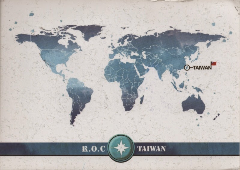
There are some very unusual maps of the world, such as Heinrich Bünting's "clover leaf" map but these two are more or less what we might expect a map of the world to look like, in spite of being very different.

The top postcard came from Lithuania and was published there. It is a reproduction of a map drawn in 1886 showing the extent of the British Empire.  The inset shows the extent of the empire in 1786.

The lower map is one, as you can see, from Taiwan, much simpler and less ornate.

Although I have a very large number of maps, they usually show individual countries or regions, much less often the whole world.

Monday, 6 April 2015

E is for Estonia


Taagepera Castle in the south of Estonia dates back to the 15th/16th century but it has been rebuilt and is now a hotel.


Järvamaa is one of the regions or counties of Estonia, pretty much in the centre of the country.

I always post a map card on a Monday if I possibly can, so here we have two cards from Estonia with map inserts.

Estonia is a country whose name I knew, vaguely, until I started exchanging postcards through Postcrossing and through many of these cards I have learned a lot.  The total population is only 1.3 million (compare that with the population of London - 8.3 million) and yet something like 10% of that population are members of Postcrossing.  I suspect only Finland can beat that percentage.

The country has Latvia to the south and Russia to the east.  Over history it has been part of Denmark, Sweden, Germany, and then the USSR.  Now of course it is an independent country and a member of the European Union.

At first it seemed amazing to have to change allegiance so often but of course Britain was invaded by Romans, Angles, Saxons, Jutes, and Vikings before the French arrived in 1066.

Monday, 30 March 2015

Map of China

Map of China on a red background with provinces marked in different patterns


A recently arrived map of China. I am very taken witht he different patterns for what I assume are different provinces of China.  It would have been nice if there had been a key.

Monday, 23 February 2015

County Clare in Ireland

Map of County Clare, Ireland, with inserted views

It's a map so it must be Monday!

As you can see on the card, County Clare is on the west coast of Ireland.  Clare is probably best known for the Cliffs of Moher, also pictured on the card.

Monday, 16 February 2015

Map of Bulgaria


I don't have very many cards from Bulgaria so I'm delighted that this arrived recently, sent by a Russian living in Bulgaria.

Monday, 29 December 2014

Seoul


A pictorial map of Seoul, the capital of South Korea.

The Floating Island in the River Han is in fact made up of three artificial islands built between 2009 and 2010.  They provide spaces for performing arts, entertainment and events, and water sports.

At the other end of the spectrum is Gyeongbok Palace which was built in 1395.  It has been undergoing restoration since 1990 after 90% of the buildings were destroyed in the early 20th century while Japan occupied the country.

Monday, 15 December 2014

Cracow


A map of the old city of Cracow or Kraków which, dating from the Stone Age, is one of the oldest cities in Poland.  The historic centre is a UNESCO World Heritage Site.

Monday, 1 December 2014

New Jersey


Because I was away for quite a while, I made my Postcrossing account inactive.  When it reverts to being active, I always receive several cards from the same country, usually, the Big Four of Germany, Russia, USA, and the Netherlands.

This time it happened again and four arrived from the USA with consecutive IDs.  And two of them were the map card above.  I couldn't even start to calculate the odds of that happening but it strikes me that it's an enormous coincidence.

One day I hope to receive a card from Deal, New Jersey, for the simple reason that I live in Deal too.

Monday, 24 November 2014

Tarn et Garonne


As today is the 150th birthday of Toulouse-Lautrec, I attempted to find a map of the area around Albi in the Tarn département (south west France) where he was born.  I failed but here instead is a map of Tarn et Garonne the next département along to the west.  Albi is almost directly to the east of Montauban.


Henri Toulouse-Lautrec was an artist, now probably best known for his posters such as the one above advertising the Moulin Rouge.

Monday, 3 November 2014

Menorca


Menorca is one of the group of islands called the Balearic Islands in the Mediterranean Sea.  The others of this group are Majorca, Ibiza, Formentera and Cabrera, plus a number of much smaller islands.  They form an autonomous province of Spain but each of the four larger islands has its own administrative council.

Menorca itself is the third largest of the islands and is largely unspoilt and has been designated a UNESCO biosphere reserve,.  Something interesting that I have only recently found out: it was a British possession three times during the 18th century and some British influence can still be seen today in the architecture and language, words such as "grevi" meaning gravy!

A map for Monday.

Monday, 27 October 2014

Sylt, in Germany

cartoon style map of Sylt


Sylt is an island off the coast of Germany in the North Sea.  Historically it was part of the Jutland peninsula which is mainly Denmark.  It is another of those places that has changed nationality a number of times.  There is a unique language, Söl'ring, spoken on the island and it's even taught in primary schools.  It is a North Frisian dialect with a strong Danish influence and with elements of Dutch and, curiously, English.

Monday, 20 October 2014

Raplamaa


Unfortunately I know little about Estonia and even less about Raplamaa, one of the 15 subdivisions or counties of Estonia. It lies slightly to the west of central Estonia.

A map for Monday.

Monday, 13 October 2014

A map of Cracow


The extent of the old city centre of Cracow or Krakow, shows very clearly on this map card.  It really is ancient - it dates back as far as the 7th century.  the entire town is a UNESCO World Heritage Site and has been since 1978.

The numbers refer to places of interest which are listed on the reverse of the card.

Monday, 6 October 2014

Eure et Loire


This map shows the Département of Eure et Loir, just to the south west of Paris and Versailles, and it is where I stopped off for a 36 hour visit to the beautiful ancient city of Chartres and its wonderful UNESCO listed cathedral.

A map for Monday - after a long break
Related Posts Plugin for WordPress, Blogger...